![](/images/other/stat-length.png)
![Trail Walking Le Perthus - Ballade autour du fort de Belgarde - Photo](https://media.geolcdn.com/t/1900/400/ext.pjpeg?maxdim=2&url=https%3A%2F%2Fstatic1.geolcdn.com%2Fsiteimages%2Fupload%2Ffiles%2F1553511878bg_sport_marche.png)
Ballade autour du fort de Belgarde
nandaf
User
![Length](/images/other/stat-length.png)
Length
5.7 km
![Max alt](https://static1.geolcdn.com/siteimages/upload/files/1508320355ic_sort_altitude_max_24dp.png)
Max alt
385 m
![Uphill gradient](https://static1.geolcdn.com/siteimages/upload/files/1508320355ic_sort_den_pos_24dp.png)
Uphill gradient
158 m
![Km-Effort](/images/other/stat-length.png)
Km-Effort
7.9 km
![Min alt](https://static1.geolcdn.com/siteimages/upload/files/1508320355ic_sort_altitude_min_24dp.png)
Min alt
300 m
![Downhill gradient](https://static1.geolcdn.com/siteimages/upload/files/1508320355ic_sort_den_neg_24dp.png)
Downhill gradient
158 m
![Boucle](https://static1.geolcdn.com/siteimages/upload/files/16400158638029165_repeat_loop_refresh_sync_direction_icon.png)
Boucle
Yes
Creation date :
2019-09-17 06:33:39.826
Updated on :
2019-09-17 06:33:39.826
![Walking](https://static1.geolcdn.com/sitytour/trail-icons/101.png)
2h00
Difficulty : Medium
![Scan this QR Code to open this trail in the SityTrail application](https://capi.geolives.com/qq0zvz2zws4bq2lad0pu/sitytour/trails/1041960/qr.png?size=200)
FREE GPS app for hiking
About
Trail Walking of 5.7 km to be discovered at Occitania, Pyrénées-Orientales, Le Perthus. This trail is proposed by nandaf.
Description
Accès: Depuis Perpignan, gagner le Pertus par la D900.
Se garer au parking P2 (indiqué dans le village).
Balisage: PR (jaune)et GR (jaune et rouge)
Positioning
Country:
France
Region :
Occitania
Department/Province :
Pyrénées-Orientales
Municipality :
Le Perthus
Location:
Unknown
Start:(Dec)
Start:(UTM)
488567 ; 4701332 (31T) N.
Comments
Trails nearby
![Trail Walking Les Cluses - LES CLUSES 66 - Photo](https://media.geolcdn.com/t/375/260/ext.jpg?maxdim=2&url=https%3A%2F%2Fstatic1.geolcdn.com%2Fsiteimages%2Fupload%2Ffiles%2F1553511878bg_sport_marche.png)
![Walking Walking](https://static1.geolcdn.com/sitytour/trail-icons/101.png)
LES CLUSES 66
Walking
Easy
(10)
Les Cluses,
Occitania,
Pyrénées-Orientales,
France
![](/images/other/stat-length.png)
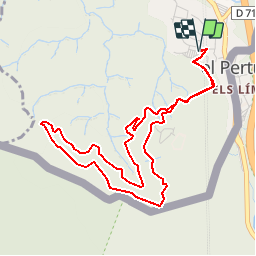
9.4 km | 12.8 km-effort
1h 50min
![](https://static1.geolcdn.com/siteimages/upload/files/16400158638029165_repeat_loop_refresh_sync_direction_icon.png)
Yes
![Trail Walking Saint-Jean-Pla-de-Corts - 66 ST-JEAN-PLA-DE-CORTS, promenade autour du Tech, jusqu'au BOULOU - Photo](https://media.geolcdn.com/t/375/260/ext.jpg?maxdim=2&url=https%3A%2F%2Fservices.sitytrail.com%2FGeolivesWS%2FDownloadMedia.ashx%3FTrailID%3D519982%26Media%3D20160131140429.jpg)
![Walking Walking](https://static1.geolcdn.com/sitytour/trail-icons/101.png)
66 ST-JEAN-PLA-DE-CORTS, promenade autour du Tech, jusqu'au BOULOU
Walking
Easy
(1)
Saint-Jean-Pla-de-Corts,
Occitania,
Pyrénées-Orientales,
France
![](/images/other/stat-length.png)
7.9 km | 8.8 km-effort
1h 18min
![](https://static1.geolcdn.com/siteimages/upload/files/16400158638029165_repeat_loop_refresh_sync_direction_icon.png)
Yes
![Trail Walking L'Albère - SAINT-JEAN-D'ALBERE 66 - PUIG de Sant Christau par le coll de Sant Joan - Photo](https://media.geolcdn.com/t/375/260/ext.jpg?maxdim=2&url=https%3A%2F%2Fservices.sitytrail.com%2FGeolivesWS%2FDownloadMedia.ashx%3FTrailID%3D452444%26Media%3D20150731170134.jpg)
![Walking Walking](https://static1.geolcdn.com/sitytour/trail-icons/101.png)
SAINT-JEAN-D'ALBERE 66 - PUIG de Sant Christau par le coll de Sant Joan
Walking
Difficult
(1)
L'Albère,
Occitania,
Pyrénées-Orientales,
France
![](/images/other/stat-length.png)
10.1 km | 17 km-effort
2h 46min
![](https://static1.geolcdn.com/siteimages/upload/files/16400158638029165_repeat_loop_refresh_sync_direction_icon.png)
Yes
![Trail Walking Les Cluses - LES CLUSES 66 - LE PERTHUS - - Photo](https://media.geolcdn.com/t/375/260/ext.jpg?maxdim=2&url=https%3A%2F%2Fstatic1.geolcdn.com%2Fsiteimages%2Fupload%2Ffiles%2F1553511878bg_sport_marche.png)
![Walking Walking](https://static1.geolcdn.com/sitytour/trail-icons/101.png)
LES CLUSES 66 - LE PERTHUS -
Walking
Medium
(2)
Les Cluses,
Occitania,
Pyrénées-Orientales,
France
![](/images/other/stat-length.png)
14.4 km | 20 km-effort
2h 57min
![](https://static1.geolcdn.com/siteimages/upload/files/16400158638029165_repeat_loop_refresh_sync_direction_icon.png)
Yes
![Trail Walking Le Perthus - penissar - Photo](https://media.geolcdn.com/t/375/260/db553a64-848c-49b3-ac51-caf4a414d04b.jpg&format=jpg&maxdim=2)
![Walking Walking](https://static1.geolcdn.com/sitytour/trail-icons/101.png)
penissar
Walking
Difficult
Le Perthus,
Occitania,
Pyrénées-Orientales,
France
![](/images/other/stat-length.png)
10.8 km | 15.1 km-effort
5h 50min
![](https://static1.geolcdn.com/siteimages/upload/files/16400158638029165_repeat_loop_refresh_sync_direction_icon.png)
Yes
![Trail Walking L'Albère - autour de St Martin l'albere et puig forcadell - Photo](https://media.geolcdn.com/t/375/260/b324b8df-ddba-4fc1-aa12-cfac2513f360.jpg&format=jpg&maxdim=2)
![Walking Walking](https://static1.geolcdn.com/sitytour/trail-icons/101.png)
autour de St Martin l'albere et puig forcadell
Walking
Difficult
L'Albère,
Occitania,
Pyrénées-Orientales,
France
![](/images/other/stat-length.png)
10.3 km | 16.5 km-effort
4h 59min
![](https://static1.geolcdn.com/siteimages/upload/files/16400158638029165_repeat_loop_refresh_sync_direction_icon.png)
Yes
![Trail Walking Maureillas-las-Illas - RIUNOGUES PORTELL PANISSAR - Photo](https://media.geolcdn.com/t/375/260/4c8ab771-8eed-403d-8d61-1b30ad4c486f.jpg&format=jpg&maxdim=2)
![Walking Walking](https://static1.geolcdn.com/sitytour/trail-icons/101.png)
RIUNOGUES PORTELL PANISSAR
Walking
Medium
(1)
Maureillas-las-Illas,
Occitania,
Pyrénées-Orientales,
France
![](/images/other/stat-length.png)
18 km | 26 km-effort
4h 35min
![](https://static1.geolcdn.com/siteimages/upload/files/16400158638029165_repeat_loop_refresh_sync_direction_icon.png)
Yes
![Trail Walking Le Perthus - perthus . panissars . redoute . bellegarde . redoute (court) - Photo](https://media.geolcdn.com/t/375/260/106b6c9e-e397-4f0d-82c9-65a8498b5486.jpg&format=jpg&maxdim=2)
![Walking Walking](https://static1.geolcdn.com/sitytour/trail-icons/101.png)
perthus . panissars . redoute . bellegarde . redoute (court)
Walking
Medium
(1)
Le Perthus,
Occitania,
Pyrénées-Orientales,
France
![](/images/other/stat-length.png)
6.6 km | 9.1 km-effort
2h 39min
![](https://static1.geolcdn.com/siteimages/upload/files/16400158638029165_repeat_loop_refresh_sync_direction_icon.png)
Yes
![Trail Walking la Jonquera - 20230427 au départ du Perthus-crash DC6 1986 - Photo](https://media.geolcdn.com/t/375/260/c1fe57ed-124b-4cbe-9732-771cc398fda1.jpg&format=jpg&maxdim=2)
![Walking Walking](https://static1.geolcdn.com/sitytour/trail-icons/101.png)
20230427 au départ du Perthus-crash DC6 1986
Walking
Difficult
la Jonquera,
Catalonia,
Girona,
Spain
![](/images/other/stat-length.png)
13.9 km | 21 km-effort
3h 54min
![](https://static1.geolcdn.com/siteimages/upload/files/16400158638029165_repeat_loop_refresh_sync_direction_icon.png)
Yes